Cork Mountaineering Club

Cork’s longest established Hill Walking Club

Month: September 2018

Sunday 23 September: PAIRED WALKS Galtees

  • Galty Wall-Galtymore (Grade 3)

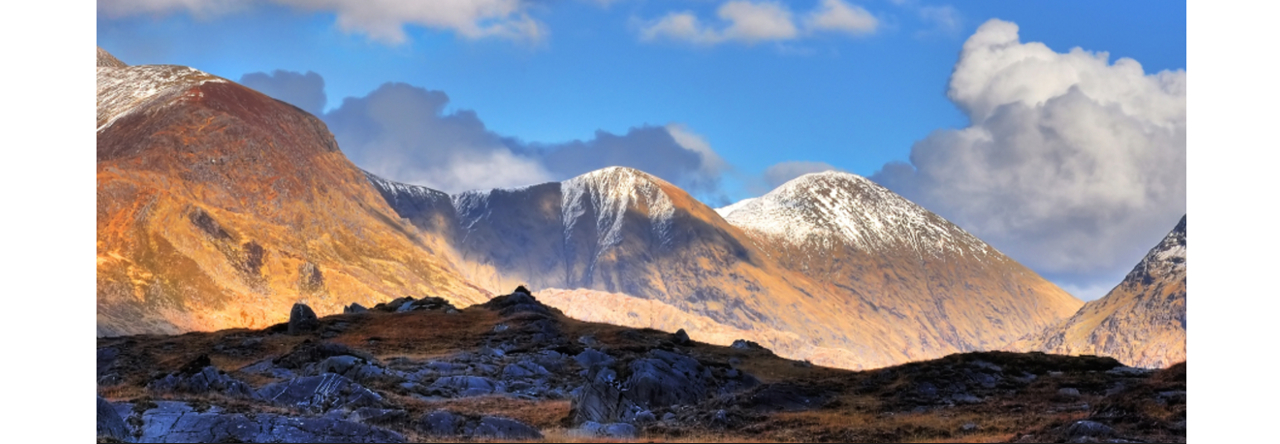
Seven members set out from King’s Yard on what turned out to be a superb walk. Weather conditions were perfect, so there was no short-cutting this great route.  In spite of the glorious sunshine, it was bitterly cold on the ridge so a cracking pace was maintained for the day.  From arrival at the Galtee Wall it was full speed ahead along the ridge, over Carrignabinnia, Slievecushnabinnia, Dawson’s Table and on to Galtymore itself (919m).  There were spectacular views in all directions; Lough Curra, the Glen of Aherlow, the Comeraghs and the Knockmealdowns.  The thrilling sight of a lone stag, preening himself for the rutting season, reminded us that Autumn is just around the corner.  It was a very happy group that arrived back in King’s Yard to enjoy coffee in the sunshine with their friends from the shorter walk.

20180923_120006 20180923_133128 (1) MAO_7428 MAO_7443 MAO_7447 MAO_7448

  • Attychraan Glen-Seefin (Grade 1/ 2)

On a fine clear day seven members  headed for Seefin, a peak that is frequently overlooked by those aspiring to greater challenges.  We made good progress to the col, and then went South to the rocky top. Perched over the Black Road (the gateway to the Galtees) we had wonderful views of the Knockmealdowns, Comeraghs and the extended Galty range. We then retraced our steps northwards and headed for Knockeenatonge, taking in lunch in a sunny spot. We descended from Knockeenatonge to the memorial stone, marking an air crash in September 1976.   Onwards in a westerly direction towards Coopers Wood, from there we followed the Attychraan river path back to King’s Yard.  En route we saw the Fly Agaric toadstool (Amanita muscaria) a flamboyantly handsome plant, but highly poisonous.  The longer walk arrived back soon afterwards.  It was a pleasure to sit down together in King’s Yard in the sunshine, and exchange stories of the day over a cuppa.

IMG-20180923-WA0022

20180923_133428

IMG-20180923-WA0009

  • And the social side  . . .

20180923_160803

20180923_16053520180923_160643

Sunday 16 September, 2018: Sugarloaf (Glengarriff) (Grade 2)

It was a terrific day, with perfect weather and magnificent views.  Seven members set off along the Beara Way track, climbing steadily to the col just west of Sugarloaf.  From there, it was a challenging out-and-back route to the summit itself over the uniquely boggy and rocky terrain of West Cork. En route, we encountered a young French “WOOF”er who was delighted with both weather and views, and a solitary local walker, who must have been turbo-powered he was going so fast!  He kindly took our summit photo.  It was a very happy and satisfied group that adjourned to Glengarriff afterwards for a well-deserved meal.

CB98564A-91BF-41A6-83E3-E4EA5582FA3E IMG_0053 IMG_3333 IMG_3336 IMG_3338

Saturday 08 September 2018: Knocknafallia & Bottleneck Pass (Grade 1/ 2)

20180908_133729 20180908_135127 20180908_135148 20180908_141956More bad-weather navigation practice!    Six members gathered at Mount Melleray Abbey at 10.30am in murky weather for the planned trek.  The poor weather forecast had caused cancellation of a silage demo at the Abbey but a few farmers had arrived and one CMC walker promised to meet them at the “Ploughing” next week … perhaps a good prospect of road frontage?    Low cloud and drizzle followed us through the woods then we broke free of the trees, crossing a newly cut firebreak and ascending over short heather with occasional low marker stones created by scouting groups.  It began to rain steadily and a SW tailwind accompanied us as we were immersed in the cloud layer. Shortly after noon we reached the summit tableland at 650 metres but by now we were propelled by strong wind and driving rain so we crossed the plateau to the northern side in search of very marginal shelter in peat tussocks. Stopping for a quick “one sandwich” lunch we were all pretty wet and the leader was deaf to mutterings of turning back.

Resuming the walk and using the handy cairn at NW edge of the plateau we descended roughly northwest into the driving rain and low cloud following a line of small cairns that lead down to the pass between Knocknafallia and the unseen Knocknagauve.  This side of the mountain is softened by long grassy tussocks making descent easy and after a time we came on the long earthbank that warns of the approaching Bottleneck Pass.  Crossing the earthbank we descended further but now swung southwest into the wind and rain on a compass bearing over rougher ground but unable to see anything but our immediate surroundings. This part of the walk was a plod into the unknown with the consolation that we were steadily descending and would eventually emerge from the murk.  A brightening coincided with easing of the rain and before us we could identify the low hill of Dyrick and the ravines that would merge above the feeder lavada canal for Melleray.  Bridging a stream by an abandoned aqueduct we searched further downstream and found the source and inlet grid of the canal. The rain had stopped; we stopped as well and sat down to a second lunch and the water-music of a stream in spate.   Our return journey followed the track beside the canal that appeared to almost flow uphill at one point and later crossed by a small aqueduct before entering the treeline and reaching a forest road. Here we swung left and soon rejoined the morning’s route back to the Abbey grounds.   Changed into drier clothes we retired to the Abbey coffee shop for scones and refreshment.  A walk memorable in retrospect.

Sunday 02 September 2018: Knockshane Circuit (Grade 2)

Yet again, last Sunday provided us with the opportunity to show off our bad-weather navigation skills and proved the benefit of identifying alternative/ escape routes at the recce stage.  The day began with five members ascending to Sugarloaf via Grubb.  Weather deteriorated however and, by the time we arrived at Knockmealdown (794m), the sky had fallen leaving us with no views.  After lunch we met with a solitary Dub, on his second day’s walk in the area but in a hurry to see the match, and he kindly took our photo – which has since disappeared into a “cyber-mist”.  The attempt to head northwards onto Knockshane did not go well.  We found ourselves descending steeply and, as it didn’t feel right, we re-traced our steps.  Thoroughly soaked by now, we decided to return to the Vee by the St Declan’s Way track.  The walk took longer than expected but despite the rain and wind all appeared to be happy to have come out on the day.

Sunday 26 August: PAIRED WALKS: Hungry Hill (Grade 3) and Bere Island (Grade 1)

  • Hungry Hill (Grade 3)                                                                                          A group of five set out on a wet and misty day. The rain stopped and the mist lifted as we made our way east along the Beara Way. We then headed north which took us close to Coomarkane Lake, from where we made our way up (west) through the rocks and gullies to the high point 667m where we had lunch, joined by our three friends wind, rain and mist. Visibility was very poor as we made our way to the top of Hungry Hill, and even poorer as we headed NW.  Before too long we realised we were not quite where we should be, but after taking a position check thanks to our Garmin we were back on track in a few While walking west towards Glas Loughs we spotted a sheep trapped upside down between two rocks, with her legs kicking madly and no chance of escape. Only one thing for it, a leg (of lamb) each, and haul her straight up. She scrambled a few feet away from us, looked back then trotted away. We headed on down to the green road feeling pleased with our good deed for the day, and followed that road straight down to the main road at the Church. Our walk took just over six hours, so we were very glad to head to Glengarriffe for some refreshments and to meet the Oileán Mór group who had only arrived in ten minutes earlier. Over the meal we decided to christen the sheep – Lucky Lady.
  • MAO_6986 MAO_6987 MAO_6988
  • Bere Island (Grade 1)                                                                                              Ten members set off on the ferry from Castletownbere to Bear Island.  Those who could made use of their free travel pass, remarking that the poor ferryman wasn’t making much profit on the trip!  We walked towards the lighthouse, where we had our lunch.  Luckily the weather stayed dry after very heavy showers the night before.  We then walked along the spine of the island, passing the remains of an old Napoleonic watch tower, deserted military installations and beautiful views over three different peninsulas.  We had coffee in the café near the pier.  Finally we met up with the Hungry Hill group in Glengarriff and shared a meal.
  • img004 img005

Sunday 19 August: Galtymore (Grade 2)

There were three members out today.  We walked up the track from the sheep pens, then onwards to the summit.   We came down via the Black Road and then through Cooper’s Wood to King’s Yard.  It was a good day out.

Saturday 11 August: Temple Hill (Grade 2)

Just four of us met at Firgrove Hotel for the wet and misty morning promised by the Met Office.  We headed to the high carpark on Monabrac, en route noting traffic heading for King’s Yard where IMRA mountain runners had a testing Galtees event.                                                                                                                                Setting-off at 10.25 in raingear we descended westwards from Monabrac to Pigeonrock river and then upstream bearing left of Knockaterriff. Ground conditions were still very firm after the prolonged drought and taking advantage of the low water level we crossed the stream and began a laborious ascent into the cloudbase and the unseen ridge which was reached about 11.45 and our first rest for a quick cuppa. Easier progress northward along the ridge in the mild wet misty conditions with a gentle SE tailwind until at 12.45 we had arrived at Temple Hill and a sheltered lunch stop in lee of the summit cairn at 785 metres.                              Still nothing visible of our surrounding hills and I decided against the direct but steep and slippery descent eastwards to the 600 metre col below Knockaterriff. Instead we descended northwards for five minutes then veering to our right but still descending over relatively easy ground of long grass and heather and avoiding occasional boulder patches.  Still seeing no sign of the invisible col or other hills we halted after 40 minutes to review our situation and to admit that we were technically lost as we didn’t know our exact position. However we were certain we could only be on the eastern side of Templehill and by distance covered we had to be above the level of the col and Pigeonrock valley.  We continued descending SE but more steeply and eventually could see the valley and stream appear out of the mist. A GPS confirmed our down valley position as just above our morning stream crossing.  The remainder of our trek retraced the morning’s route and we were back at the car park at 3pm wet but surprisingly satisfied.


Sunday 05 August: Mangerton (Grade 2)

There were record numbers out today: 21 in all.  All made it to the Punchbowl; five remained there, to descend at their leisure.  16 continued up the arête to the summit, where they had great views.  It was a very enjoyable day and all came down safely.  The group stopped in Macroom for refreshments on the way home.

DSC_5760 DSC_5779 DSC_5782 DSC_5804 DSC_5826

Summer Evening Walks

Our Summer Evening Walks continue to be popular. We had three of them in August; Charles Fort, the Estuary Walk and a lovely walk in East Ferry. The Charles Fort walk was limited by bad weather and poor visibility (though a Naval vessel was spotted at sea) and, though the weather was good for the other two walks, the evenings are certainly drawing in.  Nevertheless, canoeists and a stray seal were spotted in the harbour.  A fitting end to a wonderful season!

IMG-20180830-WA0002

Sunday 29 July 2018: Caherconree & Baurtregaum (Grade 3)

Eight members came on this trek up the Derrymore Glen.  Having all assembled at Derrymore Strand car park we set off for the mouth of the glen visible above us. Crossing the Dingle Way path and over the outlet moraine and into the glen we made good progress to the small lakes with the remains of 19th century dams used to supply water power for a mill at the mouth of the river. After some refreshments it was a steep climb to the ridge between Gearhane and Caherconree, where we had great views of the surrounding hills and seascapes.  On then over Caherconree along a narrow ridge to the saddle before ascending to Baurtregaum.  We rested a while on the summit before tackling the descent over Scragg and some rough ground with long vegetation to the Dingle Way once again. Back at the strand some of the group had a dip in the sea to restore tired muscles.  Weatherwise the day was a mixture of wind and sun some low clouds and showers towards evening. We all finished the outing with a well-deserved meal in Blennerville.

20180729_112807 20180729_114612

Designed by FriendlyComputers.ie